WBBSE Class 10 History Question Answer West Bengal Board
WBBSE Class 10 History Book Solutions West Bengal Board in English Medium
WBBSE Class 10 History Book Solutions West Bengal Board in Hindi Medium
West Bengal Board Class 10 History Question Papers
WBBSE Class 10 History Syllabus West Bengal Board 2023
Chapter 1 Ideas of History
Varieties of History: New Social History, History of Sports, History of Food habits and Cuisine, History of Performing Arts (Music, Dance, Drama, Cinema), History of Clothing, History of Transportation, History of Visual Arts (Painting, Photography), History of Architecture, Local History, Urban History, Military History, History of Environment, History of Science-Technology and Medicine, Women’s History – Discuss the main features of these different trends of history writing. (Relevant and contextual pictures and illustrations, newspaper reporting, etc.).
Methods of using sources in relation to Modern Indian History:
Government Documents (reports/narratives/letters of police/intelligence/government officials).
Autobiography and memoirs (Sattar Bathsar, Bipinchandra Pal; Jibansmrity, Rabindranath Tagore; Jibaner Jharapata, Sarala Devi Choudhurani).
Correspondence (Jawaharlal Nehru’s letters to Indira Gandhi-Letters from a Father to His Daughter)
Periodicals and Newspapers (Bangadarshan and Somprakash) – Short discussion on methods of using these types of sources in relation to Modern Indian History.
Did you know? Importance of Photography in Modern Indian History
Use and abuse of the Internet in collecting historical information
(Relevant and contextual pictures and illustrations, newspaper reporting, etc.).
Part 1 Towards a New Collectivity
Chapter 2 Reform: Characteristics and Observations
19th Century Bengal: Reflections of Society in Periodicals, Newspapers, and Literature: Bamabodhini, Hindu Patriot and Hutom Pyanchar Naksha, Nildarpan, Grambarta Prakashika – Emphatically discuss these particular texts in relation to the general context. (Relevant and contextual illustrations, newspaper reporting, etc.)
19th Century Bengal – Educational Reforms: Characteristics and Observations: Conflicts between Oriental and Western Education, Growth of English Education, Women’s Education, and Iswarchandra Vidyasagar – Discussion should revolve around these issues. Particular emphasis should be given to these four topics: Initiatives for the spread of Western Education: Raja Rammohan Ray and Raja Radhakanta Deb, Initiatives for the spread of Western Education: David Hare and John Elliot Drinkwater Bethune, Calcutta Medical College and the Development of Medical Science, Calcutta University and the Growth of Higher Education.
Did you know? Madhusudan Gupta
(Relevant and contextual pictures and illustrations, newspaper reporting, etc.).
19th Century Bengal – Social Reforms: Characteristics and Observations: Activities of Brahma Samaj and its different denominations, Anti-Sati Movement, ‘Young Bengal’, Widow Remarriage Movement – Discuss these issues, contextually and briefly.
Did you know? Haji Mohammad Mohsin
(Relevant and contextual pictures and illustrations, newspaper reporting, etc.)
19th Century Bengal – Religious Reforms: Characteristics and Observations: Brahma Movement – Evolution, Divisions, Characteristics and Observations; Ramarkrishna’s ideas of Sarva Dharma Samanwaya (religious harmony); Swami Vivekananda’s ideas of Religious Reforms: Navya Vedanta (Neo Vedanta) – Characteristics and Observations.
Did you know? Lalan Faqir, Bijay Krishna Goswami
(Relevant and contextual pictures and illustrations, newspaper reporting, etc.).
Nature and Assessment of the ‘Bengal Renaissance’, Debates regarding the usage of the concept of Renaissance’ in relation to 19th Century Bengal:
(Relevant and contextual pictures and illustrations, newspaper reporting, etc.)
Chapter 3 Resistance and Rebellion: Characteristics and Analyses
A brief introduction to the Colonial Forest Law and reactions of the Adivasi people; in that context discuss the concepts of Rebellion, Uprising, and Revolution. Chuar Rebellion (second phase, Medinipur, 1798-1799), Kol Rebellion (1831-1832), Santhal Hool (1855-1856), Munda Rebellion (1899-1900) – Characteristics and Analyses of these Rebellions with very brief narratives.
Did you know? Rangpur Revolt (1783), Bhil Rebellion (1819)
(Relevant and contextual pictures and illustrations, newspaper reporting, etc, Maps with the dates and affected areas of these Rebellions and Revolts, Timeline of these Rebellions and Revolts).
Sanyasi-Fakir Rebellion (1763-1800), Wahabi-Farazi Movement in Bengal – Characteristics and Analyses of these Rebellions with very brief narratives.
Did you know? Pagal Panthi Revolt (first phase, 1825-1827), Tariqah-i-Muhammadiya
(Relevant and contextual pictures and illustrations, newspaper reporting, etc, Maps with the dates and affected areas of these Rebellions and Revolts, and Timeline of these Rebellions and Revolts).
Indigo Revolt – Characteristics and Analyses of the Revolt with a very brief narrative.
Did you know? Peasants’ Revolt in Pabna (1870)
(Relevant and contextual pictures and illustrations, newspaper reporting, etc, Maps with the dates and affected areas of these Rebellions and Revolts, and Timeline of these Rebellions and Revolts).
Chapter 4 Early Stage of Collective Action: Characteristics and Analyses
Revolt of 1857: Characteristics and Nature (Debates regarding the relationship with ideas of Nationalism) – A brief discussion. In this context emphasis should be given on the two topics; the attitudes of educated Bengali Society towards the Revolt of 1857 and the Queen’s Proclamation (1858).
(Relevant and contextual pictures and illustrations, newspaper reporting, etc, Maps with the dates and affected areas of these Rebellions and Revolts, and Timeline of these Rebellions and Revolts).
‘Age of Associations’: Characteristics and Analyses – Bangabhasa Prakashika Sabha, Landholders’ Association (ZamindarSabha), Indian Association, Hindu Mela – Discuss these four initiatives, particularly in relation to the above-mentioned context.
(Relevant and contextual pictures and illustrations, newspaper reporting, etc, Timeline of these above-mentioned Associations and other contemporary Associations).
Anandamath, Bartaman Bharat, Gora, and Bharatmata (painting) – Discuss briefly how a sense of nationalism is embedded within these works. In that context discuss the topic: Critiques of Colonial Society in Gaganendranath Tagore’s caricatures.
(Relevant and contextual pictures and illustrations, newspaper reporting, etc.).
Part 2 Multiple Voices of Collectivity
Chapter 5 Alternative Ideas and Initiatives (From mid-19th Century to the Early 20th Century): Characteristics and Observations:
Development of Printing press in Bengal: Relation between the printed text and dissemination of knowledge; Printing press as a commercial venture – discuss the initiatives taken by Upendrakishore Roychoudhury and the U.N. ROY & SONS in this context.
(Relevant and contextual pictures and illustrations, newspaper reporting, etc, Timeline of these above-mentioned processes and events).
Development of Science and Technical Education in Bengal: In that context briefly discuss the importance of the Indian Association for the Cultivation of Science, the Calcutta Science College, and the Basu Bigyan Mandir; a brief discussion on the development of Technical Education and particularly the role of the National Council of Education and the Bengal Technical Institute in that context.
(Relevant and contextual pictures and illustrations, newspaper reporting, etc, Timeline of these above-mentioned processes and events).
Critique of Colonial ideas regarding Education: A brief discussion on ideas of Rabindranath Tagore on Shantiniketan and his initiatives related to the Visvabharati; In this context discuss in short Tagore’s ideas about synthesis among Nature, Humans, and Education.
(Relevant and contextual pictures and illustrations, newspaper reporting, etc, Timeline of these above-mentioned processes and events).
Chapter 6 Peasant, Working Class, and Left Movements in 20th Century to the Early 20th Century India: Characteristics and Observations
Relations of the Indian National Congress and Left Politics with Peasant Movements in India:
Anti-Partition Movement in Bengal, Non-Cooperation Movement, Civil Disobedience Movement, and Quit India Movement – Discussion of Peasant Movements in relation to these four movements. In that context also discuss the Eka Movement and the Bardauli Satyagraha briefly.
(Relevant and contextual pictures and illustrations, newspaper reporting, etc, Timeline on these above-mentioned Movements).
Relations of the Indian National Congress and Left Politics with Working Class Movements in India: Anti-Partition Movement in Bengal, Non-Cooperation Movement, Civil Disobedience Movement, and Quit India Movement – Discussion of Working Class Movements in relation to these four movements. Discuss briefly the issue of the Workers and Peasants’ Party.
(Relevant and contextual pictures and illustrations, newspaper reporting, etc, Timeline of these above-mentioned Movements).
Nature, Characteristics, and Observations of the politics and participation of the Left in the Anti-Colonial Movements of 20th Century India
Did you know? M. N. Roy and Left Movement of India
(Relevant and contextual pictures and illustrations, newspaper reporting, etc, Timeline of these above-mentioned Movements).
Chapter 7 Movements Organized by Women, Students, and Marginal People in 20th Century India: Characteristics and Analyses
Nature, Characteristics, and Assessment of Women’s Movement in 20th Century India: Discussion of Women’s Movement in relation to the Anti-Partition Movement in Bengal, Non-Cooperation Movement, Civil Disobedience Movement and Quit India Movement. Discuss briefly the nature of women’s role in Armed Revolutionary struggles. In that context briefly discuss these topics: Deepali Sangha, Pritilata Waddedar, and Kalpana Dutta.
Did you know? Women’s Wing Indian National Army
(Relevant and contextual pictures and illustrations, newspaper reporting, etc, Timeline of these above-mentioned Movements).
Nature, Characteristics, and Assessment of Students’ Movements in 20th Century India: Discussion of Students’ Movement in Relation to the Anti-Partition Movement in Bengal, Non-cooperation Movement, Civil Disobedience Movement, and Quit India Movement. Discuss briefly the nature of students’ role in Armed Revolutionary struggles. In that context briefly discuss these topics: Anti-Circular Society, Bengal Volunteers, Surya Sen, Bina Das, Rashid AN Day.
(Relevant and contextual pictures and illustrations, newspaper reporting, etc, Timeline of these above-mentioned Movements).
Development of Dalit politics and Movements in 20th Century India: Nature, Characteristics and Analysis; Debate between Gandhi and Ambedkar regarding Dalit rights; Also discuss briefly the Namasudra Movement in Bengal.
(Relevant and contextual pictures and illustrations, newspaper reporting, etc, Timeline of these above-mentioned Movements).
Chapter 8 Post-Colonial India: Second Half of the 20th Century (1947-1964)
Initiatives undertaken and Controversies related to the accession of Princely States with India: (Discuss and demarcate the changing internal and external boundaries of India as a State in the context of the above-mentioned topic with two maps of India, one of 1947 and another of 1964).
Did you know? Kashmir Issue, Annexation of Hyderabad
(Relevant and contextual pictures and illustrations, newspaper reporting, etc, Timeline of these above-mentioned Movements).
Initiatives undertaken and Controversies related to the Refugee Problem in post-1947: In that context briefly discuss the topic: Partition in Autobiography and Memoirs.
(Relevant and contextual pictures and illustrations, newspaper reporting, etc, Timeline of these above-mentioned Movements).
Initiatives undertaken and Controversies related to Linguistic Reorganisation of States (Discuss and demarcate the changing internal boundaries of the Indian nation in the context of the above-mentioned topic with two maps of India one of 1948 and another of 1964)
Did you know? State Reorganisation Commission and Act (1953-1956)
Schedule of Languages in the Indian Constitution (up to 1964)
(Relevant and contextual pictures and illustrations, newspaper reporting, etc, Timeline of these above-mentioned Movements).
Guidelines for Farming Questions
The following types of questions may be framed –
- Multiple Choice Type Question (M.C.Q.) – One correct answer among four options. 1 mark for each Question.
- Very Short Answer Type Question (V.S.A.) – It may include true-false, statement, and assertion, fill in the blank, and match the column. 1 mark for each Question.
- Short Answer Type Question (S.A.) – 2 marks for each Question.
- Analytical Answer Type Question – 4 marks for each Question.
- Explanatory Answer Type Question – 8 marks for each Question. (Marks division of this type of question will be 3 + 5, 5 + 3, and 8)
History Syllabus of Class 10 West Bengal Board – Chapters at a Glance
Chapter 1 Ideas of History
History is the study of the progress of human civilizations. It is not confined to the stories of kings, dynasties, wars, and dates. History has broken the barriers of tradition and brought variety and growth in its studies. Thus History sheds light on New Social History, the History of Sports, the History of Food Habits and Cuisine, the History of Performing arts (Music, Dance, Drama, Cinema), the History of Clothing, the History of Transportation, History of Visual Arts (Painting, Photography), History of Architecture, Local History, Urban History, Military History, History of Environment, History of Science-Technology and Medicine, Women’s History, etc. This chapter also deals with Historiography i.e. the history of history writing discussing within its fold + the Rankian School, The Annales School, The Subaltern School, and The New Social History; Study of Modern India; The two main sources – primary sources (Government documents like reports, narratives, diary entries by police, etc), and the secondary sources (autobiography, memoirs; Jibansmriti, Jibaner Jharapata, Sattar Bathsar, correspondence; Letters from a father to his Daughter, Periodicals; Prabasi, Bangadarshan, Newspapers; Som Prakash) help in the reconstruction of History. Importance of photography and uses and Abuses of the Internet in collecting historical information.
Chapter 2 Reforms: Characteristics and Observations
19th century Bengal: Reflections of society through periodicals, newspapers, and literature, like Bamabodhini Patrika, Hindoo Patriot, Hutom Pyanchar Naksha, Nil Darpan, Grambarta Prakashika; Educational Reforms – (a) Role of Christian Missionaries and the Serampore Trio (b) Charter Act of 1813 (c) Anglicist and Orientalist Controversy, (d) Wood’s Despatch; setting up of Calcutta Medical College (1835) and the Universities of Calcutta, Mumbai, Madras (1857), the spread of education among women and the prominent role played by Vidyasagar, David Hare, J.E.D Bethune; Social Reform movements in the 19th century executed by the Brahmos and also the role of Young Bengal and Derozio; Religious Reforms – The Brahmo Movement and the idea of monotheism, Ramakrishna Dev’s idea of ‘Sarva Dharma Samanwaya’ and ‘Neo-Vedanta’ of Swami Vivekananda brought about religious enlightenment; Bengal-Renaissance and the intellectual awakening in 19th century Bengal. But the term is debatable.
Chapter 3
Resistance and Rebellion: Characteristics and Analyses
The victory at Plassey (1757) gave the English East India Company political control of India. The imperialist interest of the company or the British colonial power led them to execute various exploitative measures. To tap the huge natural resources of the Indian forests they formed the Indian Forest Act of 1865 and 1878 thereby depriving the tribal population of their traditional rights in the forests of India and forcing them to rise in rebellion. The imposition of the high rate of land revenue, the breaking down of the economic structure of the country, the oppression and misrule both on the peasants and landlords and zamindars, and the introduction of the sun-set law, the Permanent Settlement Act resulted in various revolts. It was these uprisings, rebellions, and revolts that eventually gave rise to the political consciousness and nationalist outlook of the people of India. Examples – Chuar Rebellion, Wahabi Movement, Indigo Revolt, etc.
Chapter 4 Early Stages of Collective Action: Characteristics and Analyses
One hundred years after the battle of Plassey (1757) in the year 1857 a Great Revolt occurred due to the accumulation of discontent and grievances in the minds of the Indians towards their oppressive and imperialist Colonial rulers. The 19th century observed the growth of collective action in India which was manifested through the Revolt of 1857, the growth of associations, patriotic literature, and works of art like paintings. The collective organization and movements that took place in that period were predominantly against the British, against the age-old superstitions and to promote nationalism. There is a great deal of controversy among historians regarding the nature of the Great Revolt of 1857. Some British historians like Maleson, John Silly, John Keay, etc called it the Sepoy Mutiny which was supported by contemporary Indians like Akshay Kumar Dutta, Durgadas Banerjee, Dadabhai Naoroji, etc. J. B. Norton, Alexander Duff, Outram, Holmes, and even V. A. Smith and Karl Marx accepted the national character of the revolt or termed it a National Revolt. The revolutionary and nationalist thinker Vinayak Damodar Savarkar called it India’s First War of Independence, while R C. Joshi and others called it a National Struggle directed by the feudal lords. The English-educated Bengali intelligentsia being influenced by Western education and reforms of the colonial government did not support the sepoys. It was as a result of the Revolt of 1857, the English East India Company’s rule in India came to an end and power was transferred to the British crown. India was brought under the British crown by the Government of India Act of 1858. Queen Victoria’s famous proclamation was announced by Lord Canning at a grand durbar at Allahabad on 1st November 1858; Before the formation of the Indian National Congress in 1885 many associations were formed in different regions of India like Bombay, Madras, and especially in Bengal namely the Bangabhasa Prakashika Sabha, Landholders ’ society, Hindu Mela, Bharat Sabha, Poona Sarvajanik Sabha, Madras Mahajan Sabha etc.; To enlighten the people in nationalist ideas and patriotism a host of literary works were composed by Bankim Chandra (Anandamath), Rabindranath Tagore (Gora), and Swami Vivekananda (Bartaman Bharat). Their books played quite a significant role in arousing political awareness among the Indians. Mention must be made of the inspirational painting of ‘Bharat Mata’ by Abanindranath Tagore and the satirical sketches and cartoons (University Machine) by Gaganendranath Tagore in this context.
Chapter 5 Alternative Ideas and Initiatives
The social, religious, political, economic, and cultural ideas that developed in the first half of the 19th century underwent a great change and gave rise to new concepts and ideas in the second half of the 19th century. With the advent of Western education, social and political awareness started playing an important role in the minds of the Indian people and society. As a result, there was a drastic change in the thought process of the Indians and alternative ideas triumphed over the practiced ones. 19th century induced nationalism and ideas of national unity among the Indians which were further promoted with the development of the Indian press. Starting from the ‘Bengal Gazettee’ of Hicky (1780) to ‘Sambad Prabhakar’ of Iswarchandra Gupta (1831), newspapers helped generate knowledge and consciousness among the primarily urban people. The development of science and technology was limited during colonial rule. As a result, initiatives were taken by different notable Indians (like Mahendra Lal Sircar, Acharya Jagadish Chandra Bose, etc.) to develop scientific knowledge and research. It was the aim of the colonial government to produce Western-educated Indians who would only serve the need to rule the country. The Indians now started criticizing this colonial concept of education and thought of replacing it with alternative ideas of spreading education. The pioneering personality in this field was Rabindranath Tagore who subsequently formed, ‘Brahmacharyashram’ and ‘Visva Bharati at Shantiniketan, Bolpur.
Chapter 6 Peasant, Working Class, and Left Movements in 20th-Century India
The imperialist attitude of the British affected the peasant community in India strongly in the first half of the 20th Century who, being subjected to a lot of oppression and exploitation, rebelled against the landlords and the imperialist Government. The labour Movement in India which was much more organized aimed against the oppression and deprivation of the workers in the hands of the factory owners. The peasants did not play any significant role in the Anti-Partition Movement but they actively participated in the Non-cooperation Movement (1920), Civil Disobedience Movement (1930), and the Quit India Movement (1942). The working class played a significant role during the Anti-Partition Movement (1905) and organized several strikes against the mill and factory owners in the period. They also participated in the Non-cooperation Movement (1920) and Civil Disobedience Movement (1930). However, their participation in the Quit India Movement (1942) was limited.
Chapter 7 Movements Organised by Women, Students, and the Marginal People in the 20th Century
The 20th century saw the participation of women, students, and marginal people like the Dalits in organizing various movements. Women’s participation could be witnessed during the Anti-Partition Movement, the Non-cooperation Movement, the Civil Disobedience Movement, the Quit India Movement, and also in the armed revolutionary movement. Most of the anti-British movements during the 20th century reached a great dimension through the participation of the student community in India. They fearlessly took part in the Anti-Partition Movement, the Non-cooperation Movement, the Civil Disobedience Movement the Quit India Movement. The revolutionary group of students in Bengal, Bihar, Maharashtra, Punjab, and Uttar Pradesh made notable contributions in India’s struggle for freedom. The movement of the marginal class or the Dalits formed another important feature of the 20th-century movements.
Chapter 8 Post Colonial India Second Half of the 20th Century (1947-1964)
After 190 years of British domination, India won independence on 15th August 1947. But by the provision of the Indian Independence Act the native rulers had the choice to accede either to Pakistan or to India. This resulted in a lot of trouble and Sardar Vallabhbhai Patel, the first Home Minister of independent India was able to merge the native states into the Indian Union. However, Pakistan refused to accept the inclusion of Kashmir to India which resulted in a number of wars, tension between the two countries, and the creation of ‘Pakistan occupied Kashmir ’. The partition of India gave rise to the problems like communal riots and the issues related to the ‘Refugees’. Both the governments of India and Pakistan tried to solve the refugee Problem through the ‘Nehru-Liaquat’ Agreement of 1950. However, the influx of refugees to India continued even after this agreement. The linguistic policies adopted by the Nehru government after independence also created problems and ultimately the government had to concede to the demands of forming states on the basis of languages. By the State Reorganisation Act of 1956, the states of India were also reorganized. Till 1964, there were 14 recognized languages mentioned in the 8th schedule of our constitution. At present, there are 22 recognized languages. Hindi and English are recognized as the official languages of India.
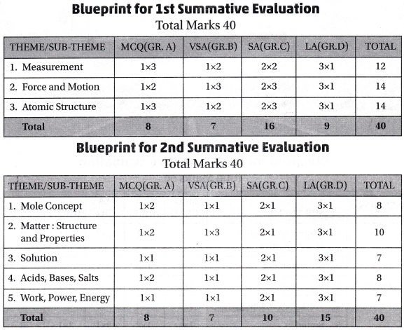
West Bengal Board Class 10 History 1st Summative Evaluation (Total Marks – 40)
Internal Formative Evaluation: (Total Marks – 10)
Month of Evaluation: April
- Chapter 1 Ideas of History
- Chapter 2 Reform: Characteristics and Observations
- Chapter 3 Resistance and Rebellion: Characteristics and Analyses
West Bengal Board Class 10 History 2nd Summative Evaluation (Total Marks – 40)
Internal Formative Evaluation (Total Marks – 10)
Month of Evaluation: August
- Chapter 4 Early Stages of Collective Action: Characteristics and Analyses
- Chapter 5 Alternative Ideas and Initiatives (From mid-19th Century to the early 20th Century): Characteristics and Observations.
- Chapter 6 Peasant, Working Class and Left Movements in 20th Century India: Characteristics and Observations
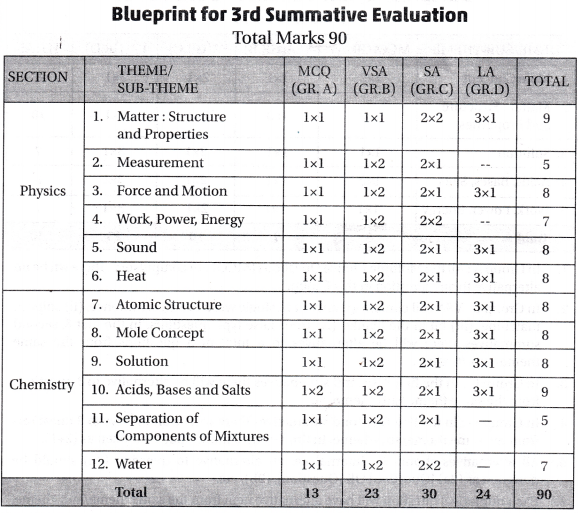
West Bengal Board Class 10 History 3rd Summative Evaluation (Total Marks – 90)
Internal Formative Evaluation (Total Marks – 10)
Month of Evaluation: December
- Chapter 7 Movements Organized by Women, Students, and Marginal People in 20th Century India: Characteristics and Analyses
- Chapter 8 Post-Colonial India: Second Half of the 20th Century (1947-1964)
Note: Chapters prescribed for the First and Second Summative Evaluations are also to be included in the 3rd Summative Evaluation
WBBSE Class 10 History Blueprint for 1st Summative Evaluation (Total Marks – 40)
| Topic |
MCQ (GR. A) |
VSA (Gr. B) |
SA (Gr. C) |
AAT (Gr. D) |
EAT (Gr. E) |
Total |
| Chapter 1 |
1 × 2 = 2 |
1 × 2 = 2 |
2 × 1 = 2 |
1 question from each chapter. Answer any 2 questions |
1 question from each chapter. Answer any 1 question |
|
| Chapter 2 |
1 × 4 = 4 |
1 × 2 = 2 |
2 × 2 = 4 |
| Chapter 3 |
1 × 4 = 4 |
1 × 2 = 2 |
2 × 2 = 4 |
| Questions to be given |
10 |
6 |
5 |
3 |
3 |
27 |
| Questions to be answered |
10 |
6 |
4 |
2 |
1 |
23 |
| Total Marks |
1 × 10 = 10 |
1 × 6 = 6 |
2 × 4 = 8 |
4 × 2 = 8 |
8 × 1 = 8 |
40 |
Note:
Group A: Consists of MCQ. Every question of this group should have four options of answer.
Group B: Should consist of very short answer-type questions (answer should be in a single sentence): True- False, Statement-Assertion. 2 questions from each item will be given (3 × 2 = 6)
Group C: Consists of short answer type conceptual questions. The answer should be in two or three sentences.
Group D: Consists of analytical answer-type conceptual questions. The answer should be in seven or eight sentences.
Group E: Consists of explanatory answer-type conceptual questions. The answer should be in fifteen to sixteen sentences. In this group marks division will be either 3 + 5 or 5 + 3 or 8.
WBBSE Class 10 History Blueprint for 2nd Summative Evaluation (Total Marks – 40)
| Topic |
MCQ (GR. A) |
VSA (Gr. B) |
SA (Gr. C) |
AAT (Gr. D) |
EAT (Gr. E) |
Total |
| Chapter 4 |
1 × 3 = 3 |
1 × 2 = 2 |
2 × 1 = 2 |
1 question from each chapter. Answer any 2 questions |
1 question from each chapter. Answer any 1 question |
|
| Chapter 5 |
1 × 4 = 4 |
1 × 2 = 2 |
2 × 2 = 4 |
| Chapter 6 |
1 × 3 = 3 |
1 × 2 = 2 |
2 × 2 = 4 |
| Questions to be given |
10 |
6 |
5 |
3 |
3 |
27 |
| Questions to be answered |
10 |
6 |
4 |
2 |
1 |
23 |
| Total Marks |
1 × 10 = 10 |
1 × 6 = 6 |
2 × 4 = 8 |
4 × 2 = 8 |
8 × 1 = 8 |
40 |
Note:
Group A: Consists of MCQ. Every question of this group should have four options of answer.
Group B: Should consist of only two items: Match the Column and map pointing**, 3 questions from each item will be given (3 × 2 = 6)
Group C: Consists of short answer type conceptual questions. The answer should be in two or three sentences.
Group D: Consists of analytical answer-type conceptual questions. The answer should be in seven or eight sentences.
Group E: Consists of explanatory answer-type conceptual questions. The answer should be in fifteen to sixteen sentences. In this group marks division will be either 3 + 5 or 5 + 3 or 8.
WBBSE Class 10 History Blueprint for 3rd Summative Evaluation (Total Marks – 90)
Madhyamik Examination
| Topic |
(GR. A) M.C.Q. each question – 1 mark |
(Gr. B) Very short answer type (V.S.A) each question – 1 mark |
(Gr. C)
Short answer type (S.A) each question – 2 marks |
(Gr. D)
Analytical answer type each question – 4 marks |
(Gr. E)
Explanatory answer type each question – 8 marks
|
|
| Chapter 1 |
1 × 2 |
1 × 2 |
2 × 2 |
2 questions from Chapter 1 or 2 |
– |
| Chapter 2 |
1 × 3 |
1 × 3 |
2 × 2 |
1 question from Chapter 2 or 3 |
| Chapter 3 |
1 × 2 |
1 × 3 |
2 × 2 |
2 questions from Chapter 3 or 4 |
| Chapter 4 |
1 × 3 |
1 × 3 |
2 × 2 |
1 question from Chapter 4 or 5 |
| Chapter 5 |
1 × 2 |
1 × 2 |
2 × 2 |
2 questions from Chapter 5 or 6 |
| Chapter 6 |
1 × 3 |
1 × 3 |
2 × 2 |
1 question from Chapter 6 or 7 |
| Chapter 7 |
1 × 3 |
1 × 3 |
2 × 2 |
2 questions from Chapter 7 or 8 |
| Chapter 8 |
1 × 2 |
1 × 1 |
2 × 2 |
– |
| Questions to be given |
20 |
20 |
16 |
8 |
3 |
67 |
| Questions to be answered |
20 |
16 |
11 |
6 |
1 |
54 |
| Total Marks |
1 × 20 = 20 |
1 × 16 = 16 |
2 × 11 = 22 |
4 × 6 = 24 |
8 × 1 = 8 |
90 |
|
|
Answer any 16 questions from 20. Have to answer from each item. |
Answer any 11 questions from 16. |
Answer a total of 6 questions from four segments. At least 1 question from each segment and another 2 from any segment. |
Answer any 1 question from 3. |
|

Note:
Group A: Consists of MCQ. Every question of this group should have four options of answer.
Group B: Should consist of True-False, Match the Column, VSA (in one sentence), Map pointing** & Statement-Assertion. 4 questions from each item will be given.
Group C: Consists of short answer type conceptual questions. The answer should be in two or three sentences.
Group D: Consists of analytical answer-type conceptual questions. The answer should be in seven or eight sentences.
Group E: Consists of explanatory answer-type conceptual questions. The answer should be in fifteen to sixteen sentences. In this group marks division of the three questions will be either 3 + 5 or 5 + 3 or 8.
*This question pattern is indicative of the Madhyamik Examination.
**For the visually challenged students, Fill in the blanks will be given as an alternative.